 Adminator
1e51ef7def
Adminator
1e51ef7def
- Konzept/, didaktik_geografie/, didaktik_simulation/, v2-modules/, v2-platform/
- 12 code-workspace-Files
- STATUS-*.md
- viele M/D/R-Änderungen an bereits getrackten Files
- .gitignore verstärkt: **/.humaninput/, **/secret_keys.txt

Co-Authored-By: Claude Opus 4.7 <noreply@anthropic.com>
93 lines
5.0 KiB
XML
93 lines
5.0 KiB
XML
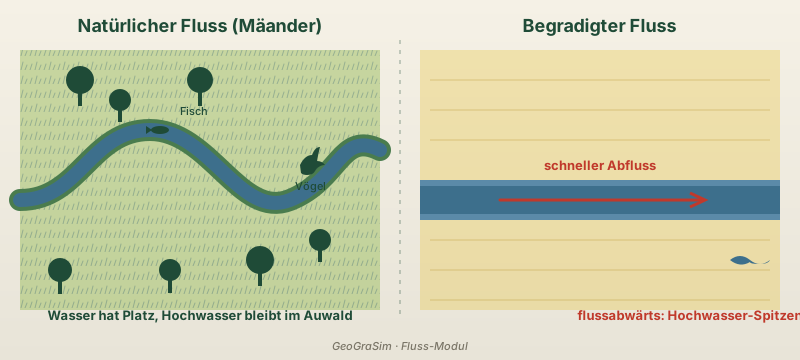


<?xml version="1.0" encoding="UTF-8"?>
|
|
<svg xmlns="http://www.w3.org/2000/svg" viewBox="0 0 800 360" role="img" aria-labelledby="title desc">
|
|
<title id="title">Mäander vs. begradigter Fluss — Vergleichsschema</title>
|
|
<desc id="desc">Links: natürlicher Fluss mit Mäander-Schleifen, Auwald und Tieren. Rechts: künstlich begradigter Fluss als gerader Kanal, ohne Lebensraum, mit Pfeil zur höheren Hochwassergefahr flussabwärts.</desc>
|
|
|
|
<defs>
|
|
<linearGradient id="bg" x1="0" y1="0" x2="0" y2="1">
|
|
<stop offset="0" stop-color="#f5f1e6"/>
|
|
<stop offset="1" stop-color="#e8e4d8"/>
|
|
</linearGradient>
|
|
<pattern id="grass" x="0" y="0" width="14" height="14" patternUnits="userSpaceOnUse">
|
|
<rect width="14" height="14" fill="#a3c167"/>
|
|
<path d="M2 14 L4 8 M7 14 L9 6 M11 14 L13 9" stroke="#4a7c4e" stroke-width="1" stroke-linecap="round"/>
|
|
</pattern>
|
|
</defs>
|
|
|
|
<rect width="800" height="360" fill="url(#bg)"/>
|
|
<line x1="400" y1="40" x2="400" y2="320" stroke="#1f4b37" stroke-dasharray="4 6" stroke-width="1.2" opacity=".4"/>
|
|
|
|
<!-- Titel -->
|
|
<text x="200" y="32" text-anchor="middle" font-family="Inter, system-ui, sans-serif" font-weight="800" font-size="18" fill="#1f4b37">Natürlicher Fluss (Mäander)</text>
|
|
<text x="600" y="32" text-anchor="middle" font-family="Inter, system-ui, sans-serif" font-weight="800" font-size="18" fill="#1f4b37">Begradigter Fluss</text>
|
|
|
|
<!-- LINKS: Auwald-Streifen -->
|
|
<rect x="20" y="50" width="360" height="260" fill="url(#grass)" opacity=".55"/>
|
|
|
|
<!-- LINKS: Mäander-Fluss -->
|
|
<path d="M20 200
|
|
C 80 200, 90 130, 150 130
|
|
S 240 220, 290 200
|
|
S 340 130, 380 150"
|
|
fill="none" stroke="#4a7c4e" stroke-width="22" stroke-linecap="round"/>
|
|
<path d="M20 200
|
|
C 80 200, 90 130, 150 130
|
|
S 240 220, 290 200
|
|
S 340 130, 380 150"
|
|
fill="none" stroke="#3d6f8c" stroke-width="14" stroke-linecap="round"/>
|
|
|
|
<!-- LINKS: Auwald-Bäume -->
|
|
<g fill="#1f4b37">
|
|
<circle cx="80" cy="80" r="14"/><rect x="78" y="92" width="4" height="14"/>
|
|
<circle cx="120" cy="100" r="11"/><rect x="118" y="110" width="4" height="12"/>
|
|
<circle cx="200" cy="80" r="13"/><rect x="198" y="92" width="4" height="14"/>
|
|
<circle cx="260" cy="260" r="14"/><rect x="258" y="272" width="4" height="14"/>
|
|
<circle cx="320" cy="240" r="11"/><rect x="318" y="250" width="4" height="12"/>
|
|
<circle cx="60" cy="270" r="12"/><rect x="58" y="281" width="4" height="13"/>
|
|
<circle cx="170" cy="270" r="11"/><rect x="168" y="280" width="4" height="13"/>
|
|
</g>
|
|
|
|
<!-- LINKS: Fisch + Reiher -->
|
|
<g>
|
|
<ellipse cx="160" cy="130" rx="9" ry="4" fill="#1f4b37"/>
|
|
<path d="M152 130 L146 126 L146 134 Z" fill="#1f4b37"/>
|
|
<text x="180" y="115" font-family="Inter, system-ui" font-size="11" fill="#1f4b37">Fisch</text>
|
|
|
|
<path d="M300 165 q5 -10 12 -10 q3 -8 8 -8 q-2 8 -3 14 q5 0 8 4 q-6 0 -10 6 q-2 4 -8 4 q-4 0 -6 -2 z" fill="#1f4b37"/>
|
|
<text x="295" y="190" font-family="Inter, system-ui" font-size="11" fill="#1f4b37">Vögel</text>
|
|
</g>
|
|
|
|
<!-- LINKS: Hochwasser-Aufweitung (Pfeil hinaus) -->
|
|
<text x="200" y="320" text-anchor="middle" font-family="Inter, system-ui" font-weight="600" font-size="13" fill="#1f4b37">Wasser hat Platz, Hochwasser bleibt im Auwald</text>
|
|
|
|
<!-- RECHTS: Acker-Streifen -->
|
|
<rect x="420" y="50" width="360" height="260" fill="#e8c547" opacity=".35"/>
|
|
<line x1="430" y1="80" x2="770" y2="80" stroke="#b8932f" stroke-width="1" opacity=".4"/>
|
|
<line x1="430" y1="110" x2="770" y2="110" stroke="#b8932f" stroke-width="1" opacity=".4"/>
|
|
<line x1="430" y1="140" x2="770" y2="140" stroke="#b8932f" stroke-width="1" opacity=".4"/>
|
|
<line x1="430" y1="240" x2="770" y2="240" stroke="#b8932f" stroke-width="1" opacity=".4"/>
|
|
<line x1="430" y1="270" x2="770" y2="270" stroke="#b8932f" stroke-width="1" opacity=".4"/>
|
|
<line x1="430" y1="300" x2="770" y2="300" stroke="#b8932f" stroke-width="1" opacity=".4"/>
|
|
|
|
<!-- RECHTS: Begradigter Kanal -->
|
|
<rect x="420" y="180" width="360" height="40" fill="#3d6f8c"/>
|
|
<rect x="420" y="180" width="360" height="6" fill="#5b8aa8"/>
|
|
<rect x="420" y="214" width="360" height="6" fill="#5b8aa8"/>
|
|
|
|
<!-- RECHTS: Pfeil schnellerer Abfluss -->
|
|
<g stroke="#c0392b" stroke-width="3" fill="none">
|
|
<line x1="500" y1="200" x2="700" y2="200" stroke-linecap="round"/>
|
|
<polyline points="690,193 705,200 690,207"/>
|
|
</g>
|
|
<text x="600" y="170" text-anchor="middle" font-family="Inter, system-ui" font-weight="700" font-size="13" fill="#c0392b">schneller Abfluss</text>
|
|
|
|
<!-- RECHTS: Hochwasser-Symbol unten -->
|
|
<g>
|
|
<path d="M730 260 q10 -8 20 0 q10 8 20 0 q-2 4 -10 4 q-10 0 -10 -2 q-10 6 -20 -2 z" fill="#3d6f8c"/>
|
|
<text x="690" y="320" text-anchor="middle" font-family="Inter, system-ui" font-weight="600" font-size="13" fill="#c0392b">flussabwärts: Hochwasser-Spitzen</text>
|
|
</g>
|
|
|
|
<!-- Beschriftung Mitte -->
|
|
<text x="400" y="350" text-anchor="middle" font-family="Inter, system-ui" font-size="11" fill="#7a7567" font-style="italic">GeoGraSim · Fluss-Modul</text>
|
|
</svg>
|