 Adminator
a425ce31e6
Adminator
a425ce31e6
- Mindmap mit Force-directed Layout (pages/mindmap.php) + Cross-Links
- 28 Eintraege im Fachartikel-Stil mit 113 Quellen + Inline-Referenzen [^n]
- Leichte-Sprache-Version fuer alle 28 Eintraege (short_easy, text_easy, examples.text_easy)
- 19 Infografiken (12 neu): co2-Keeling, klimawandel-Temp, kohlenstoff-Kreislauf, fotosynthese, energiemix-AT, methan-GWP, photovoltaik, wasserkraft, kipppunkt, biodiversitaet-LPI, permafrost, treibhausgas-GWP + bestehende (treibhauseffekt, ppm, windrad, albedo, fossile, kwh, co2-fussabdruck)
- 5 DALL-E-Reprasentationsbilder im Querformat (nachhaltigkeit, klimaneutralitaet, erneuerbare-energie, emissionen, pariser-abkommen)
- Alphabetische Sprungnavigation A-Z mit Buchstabenbannern
- Lightbox-Vollbild auf allen Infografiken mit expliziten SVG-Dimensionen (Safari/iPad-Fix)
- Easy-Sprache-Toggle pro Card mit localStorage-Persistenz
- 4 interaktive Experimente: kWh-Rennen, ppm-Finder, albedo-Slider, CO2-Fussabdruck-Rechner
- iPad-Optimierung: Touch-Ziele >=38px, Hover in @media (hover), touch-action
- Modul-Metadaten aus DB-Tabelle module_info (keine Hardcodes)
- Cache-Buster auf JS-Asset
- Schema-Erweiterung: glossar_sources, examples.text_easy

Co-Authored-By: Claude Opus 4.7 (1M context) <noreply@anthropic.com>
108 lines
6.0 KiB
XML
108 lines
6.0 KiB
XML
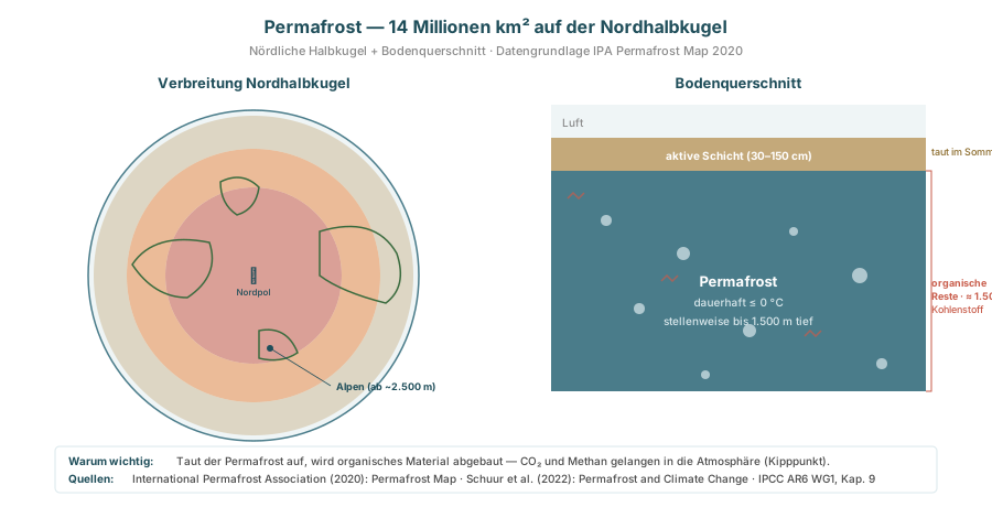


<svg xmlns="http://www.w3.org/2000/svg" viewBox="0 0 900 460" font-family="Inter, system-ui, sans-serif" width="900" height="460">
|
||
<text x="450" y="30" font-size="16" font-weight="800" fill="#1f4e5a" text-anchor="middle">
|
||
Permafrost — 14 Millionen km² auf der Nordhalbkugel
|
||
</text>
|
||
<text x="450" y="50" font-size="11" fill="#8a8a8a" text-anchor="middle">
|
||
Nördliche Halbkugel + Bodenquerschnitt · Datengrundlage IPA Permafrost Map 2020
|
||
</text>
|
||
|
||
<!-- LINKS: Polansicht Nordhalbkugel -->
|
||
<g transform="translate(60,80)">
|
||
<text x="170" y="0" font-size="13" font-weight="800" fill="#1f4e5a" text-anchor="middle">Verbreitung Nordhalbkugel</text>
|
||
|
||
<!-- Polar-Projektion als Kreis -->
|
||
<circle cx="170" cy="170" r="150" fill="#eff5f6" stroke="#4a7c8a" stroke-width="1.5"/>
|
||
|
||
<!-- Permafrost-Zonen (schematisch): kontinuierlich innen, diskontinuierlich außen -->
|
||
<!-- Kontinuierlicher Permafrost (innen) -->
|
||
<circle cx="170" cy="170" r="80" fill="#c85c4a" fill-opacity=".55"/>
|
||
<!-- Diskontinuierlich -->
|
||
<path d="M 170 170 m -115 0 a 115 115 0 1 0 230 0 a 115 115 0 1 0 -230 0 Z M 170 170 m -80 0 a 80 80 0 1 1 160 0 a 80 80 0 1 1 -160 0 Z"
|
||
fill="#e8833a" fill-opacity=".5" fill-rule="evenodd"/>
|
||
<!-- Sporadisch außen -->
|
||
<path d="M 170 170 m -145 0 a 145 145 0 1 0 290 0 a 145 145 0 1 0 -290 0 Z M 170 170 m -115 0 a 115 115 0 1 1 230 0 a 115 115 0 1 1 -230 0 Z"
|
||
fill="#c4a97a" fill-opacity=".4" fill-rule="evenodd"/>
|
||
|
||
<!-- Pol-Stern -->
|
||
<text x="170" y="175" font-size="14" font-weight="900" fill="#1f4e5a" text-anchor="middle">✦</text>
|
||
<text x="170" y="188" font-size="8" fill="#1f4e5a" text-anchor="middle">Nordpol</text>
|
||
|
||
<!-- Grobe Kontinentumrisse -->
|
||
<g fill="none" stroke="#3a6b3e" stroke-width="1.5">
|
||
<!-- Grönland -->
|
||
<path d="M 140 85 Q 160 75 175 90 Q 172 110 155 115 Q 140 105 140 85 Z"/>
|
||
<!-- Sibirien (Ost) -->
|
||
<path d="M 230 130 Q 280 115 300 150 Q 310 180 290 195 Q 250 185 230 170 Z"/>
|
||
<!-- Nord-Amerika/Kanada/Alaska -->
|
||
<path d="M 60 160 Q 80 130 130 140 Q 140 170 110 190 Q 80 190 60 160 Z"/>
|
||
<!-- Europa klein -->
|
||
<path d="M 175 220 Q 200 215 210 240 Q 195 250 175 245 Z"/>
|
||
</g>
|
||
|
||
<!-- Alpen-Markierung -->
|
||
<circle cx="185" cy="236" r="3" fill="#1f4e5a"/>
|
||
<line x1="185" y1="236" x2="240" y2="270" stroke="#1f4e5a" stroke-width=".8"/>
|
||
<text x="245" y="274" font-size="9" font-weight="700" fill="#1f4e5a">Alpen (ab ~2.500 m)</text>
|
||
|
||
<!-- Legende -->
|
||
<g transform="translate(0,340)">
|
||
<g><rect width="12" height="12" fill="#c85c4a" fill-opacity=".55"/><text x="18" y="10" font-size="10" fill="#1f4e5a">kontinuierlich</text></g>
|
||
<g transform="translate(105,0)"><rect width="12" height="12" fill="#e8833a" fill-opacity=".5"/><text x="18" y="10" font-size="10" fill="#1f4e5a">diskontinuierlich</text></g>
|
||
<g transform="translate(225,0)"><rect width="12" height="12" fill="#c4a97a" fill-opacity=".4"/><text x="18" y="10" font-size="10" fill="#1f4e5a">sporadisch</text></g>
|
||
</g>
|
||
</g>
|
||
|
||
<!-- RECHTS: Bodenquerschnitt -->
|
||
<g transform="translate(500,80)">
|
||
<text x="170" y="0" font-size="13" font-weight="800" fill="#1f4e5a" text-anchor="middle">Bodenquerschnitt</text>
|
||
|
||
<!-- Luft oben -->
|
||
<rect x="0" y="15" width="340" height="30" fill="#eff5f6"/>
|
||
<text x="10" y="35" font-size="10" fill="#8a8a8a">Luft</text>
|
||
|
||
<!-- Aktive Schicht (taut im Sommer) -->
|
||
<rect x="0" y="45" width="340" height="30" fill="#c4a97a"/>
|
||
<text x="170" y="65" font-size="10" font-weight="700" fill="#fff" text-anchor="middle">aktive Schicht (30–150 cm)</text>
|
||
<text x="345" y="61" font-size="9" fill="#8a6a2a">taut im Sommer</text>
|
||
|
||
<!-- Permafrost -->
|
||
<rect x="0" y="75" width="340" height="200" fill="#4a7c8a"/>
|
||
<!-- Eis-Einschlüsse -->
|
||
<g fill="#dae8ec" opacity=".7">
|
||
<circle cx="50" cy="120" r="5"/>
|
||
<circle cx="120" cy="150" r="6"/>
|
||
<circle cx="220" cy="130" r="4"/>
|
||
<circle cx="280" cy="170" r="7"/>
|
||
<circle cx="80" cy="200" r="5"/>
|
||
<circle cx="180" cy="220" r="6"/>
|
||
<circle cx="300" cy="250" r="5"/>
|
||
<circle cx="140" cy="260" r="4"/>
|
||
</g>
|
||
<text x="170" y="180" font-size="13" font-weight="900" fill="#fff" text-anchor="middle">Permafrost</text>
|
||
<text x="170" y="198" font-size="10" fill="#dae8ec" text-anchor="middle">dauerhaft ≤ 0 °C</text>
|
||
<text x="170" y="215" font-size="10" fill="#dae8ec" text-anchor="middle">stellenweise bis 1.500 m tief</text>
|
||
|
||
<!-- Organische Substanz markiert -->
|
||
<g>
|
||
<path d="M 15 100 L 20 95 L 25 100 L 30 95" stroke="#c85c4a" stroke-width="1.5" fill="none" opacity=".7"/>
|
||
<path d="M 100 175 L 105 170 L 110 175 L 115 170" stroke="#c85c4a" stroke-width="1.5" fill="none" opacity=".7"/>
|
||
<path d="M 230 225 L 235 220 L 240 225 L 245 220" stroke="#c85c4a" stroke-width="1.5" fill="none" opacity=".7"/>
|
||
</g>
|
||
<text x="345" y="180" font-size="9" fill="#c85c4a" font-weight="700">organische</text>
|
||
<text x="345" y="192" font-size="9" fill="#c85c4a" font-weight="700">Reste · ≈ 1.500 Gt</text>
|
||
<text x="345" y="204" font-size="9" fill="#c85c4a">Kohlenstoff</text>
|
||
|
||
<!-- Klammer rechts -->
|
||
<path d="M 340 75 L 345 75 L 345 275 L 340 275" fill="none" stroke="#c85c4a" stroke-width="1"/>
|
||
</g>
|
||
|
||
<!-- Footer -->
|
||
<g transform="translate(50,405)">
|
||
<rect x="0" y="0" width="800" height="42" rx="4" fill="#fff" stroke="#dae8ec"/>
|
||
<text x="12" y="17" font-size="10" font-weight="800" fill="#1f4e5a">Warum wichtig:</text>
|
||
<text x="110" y="17" font-size="10" fill="#4a4a4a">Taut der Permafrost auf, wird organisches Material abgebaut — CO₂ und Methan gelangen in die Atmosphäre (Kipppunkt).</text>
|
||
<text x="12" y="33" font-size="10" font-weight="800" fill="#1f4e5a">Quellen:</text>
|
||
<text x="70" y="33" font-size="10" fill="#4a4a4a">International Permafrost Association (2020): Permafrost Map · Schuur et al. (2022): Permafrost and Climate Change · IPCC AR6 WG1, Kap. 9</text>
|
||
</g>
|
||
</svg>
|